
Hurricane Wilma Becomes Category 5 Monster Heading Towards Florida
October 19, 2005 (HDW) Miami, Florida – Hurricane Wilma was reported today by the National Hurricane Center in Miami, Florida to be a dangerous Category 5 hurricane. On 17 October, Wilma did not yet have a hurricane’s typical well organized spiral structure and powerful winds, but since this time, its winds have increased to as high as 175 miles per hour and warnings are being issued throughout Florida and the Caribbean. Wilma was the 21st storm of the 2005 Atlantic Hurricane season to be named. This made 2005 the most active hurricane season on record, tied with 1933, which also had 21 named storms. Wilma’s projected course as it gained hurricane status was to continue northeast over Florida and into the Gulf of Mexico where warm waters were predicted to fuel its continuing growth.
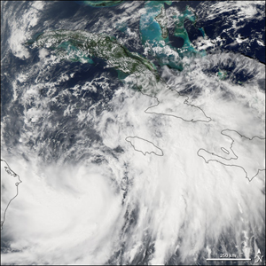
When the above picture of Hurricane Wilma was taken by a NASA satellite on 18 October, Wilma was building in power and size and developing the shape and form of a full fledged hurricane. Wilma rapidly grew afterwards and its effects are expected to be felt within the United States by the week’s end. |
|
|