
Hurricane Rita Moves Through Gulf with Category 5 Winds of 170 Mph
September 22, 2005 (HDW) Texas – Hurricane Rita is the second Category 5 storm of the 2005 Atlantic hurricane season. The first was Hurricane Katrina, which devastated much of the Mississippi, Louisiana, and Alabama shoreline, and killed over a thousand people, when it came ashore on August 29. Rita is expected to weaken slightly before coming ashore over the Texas or Louisiana coastline on September 23 or 24 as a major hurricane (Category 3 or higher).
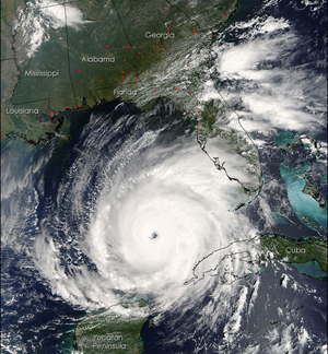
In the above image taken by a NASA satellite on 21 September, the Gulf Coast of the United States frames the open water to the north of Hurricane Rita, while the Yucatan Peninsula is visible to the south. The satellite also detected several fires, marked with red dots, burning in the southeastern United States. The fires are probably agricultural fires.
Hurricane Rita was building up to an extremely dangerous Category 5 hurricane when the NASA satellite captured this image yesterday. Rita bears the markings of a powerful hurricane: it is compact and circular with an open eye through which the deep blue waters of the Gulf of Mexico are visible. At the time this image was acquired, Rita had winds of 220 kilometers per hour (140 miles per hour) with gusts to 270 kph (170 mph). Within a few hours, the storm intensified to a Category 5 hurricane with sustained winds of 265 kph (165 mph). |
|
|