
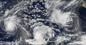
Hurricane Kenneth, Hurricane Jova, and Tropical Storm Max Spin Near California
September 23, 2005 (HDW) Baja, California – Hurricane Kenneth, Hurricane Jova, and Tropical Storm Max spun off the west coast of Baja, California on 21 September at the same time, but the storms did not come ashore and cause harm. Two NASA satellites were able to create the above picture displaying a mosaic of the storms in the eastern Pacific off the coast of Baja, California and Mexico. They are, from left to right, Hurricane Jova, Hurricane Kenneth, and Tropical Storm Max. Also shown is an intensifying tropical depression which later developed into Tropical Storm Norma, though it had not quite earned the name at the time of the picture.
The mosaic combines observations spanning the eastern Pacific from Mexico almost all the way to Hawaii. It was created by merging data obtained by both the Terra and Aqua satellites’ instruments and from two separate satellite passes each. Small gray gaps show where the image swaths did not quite overlap. |
|
|